a departure (2025).
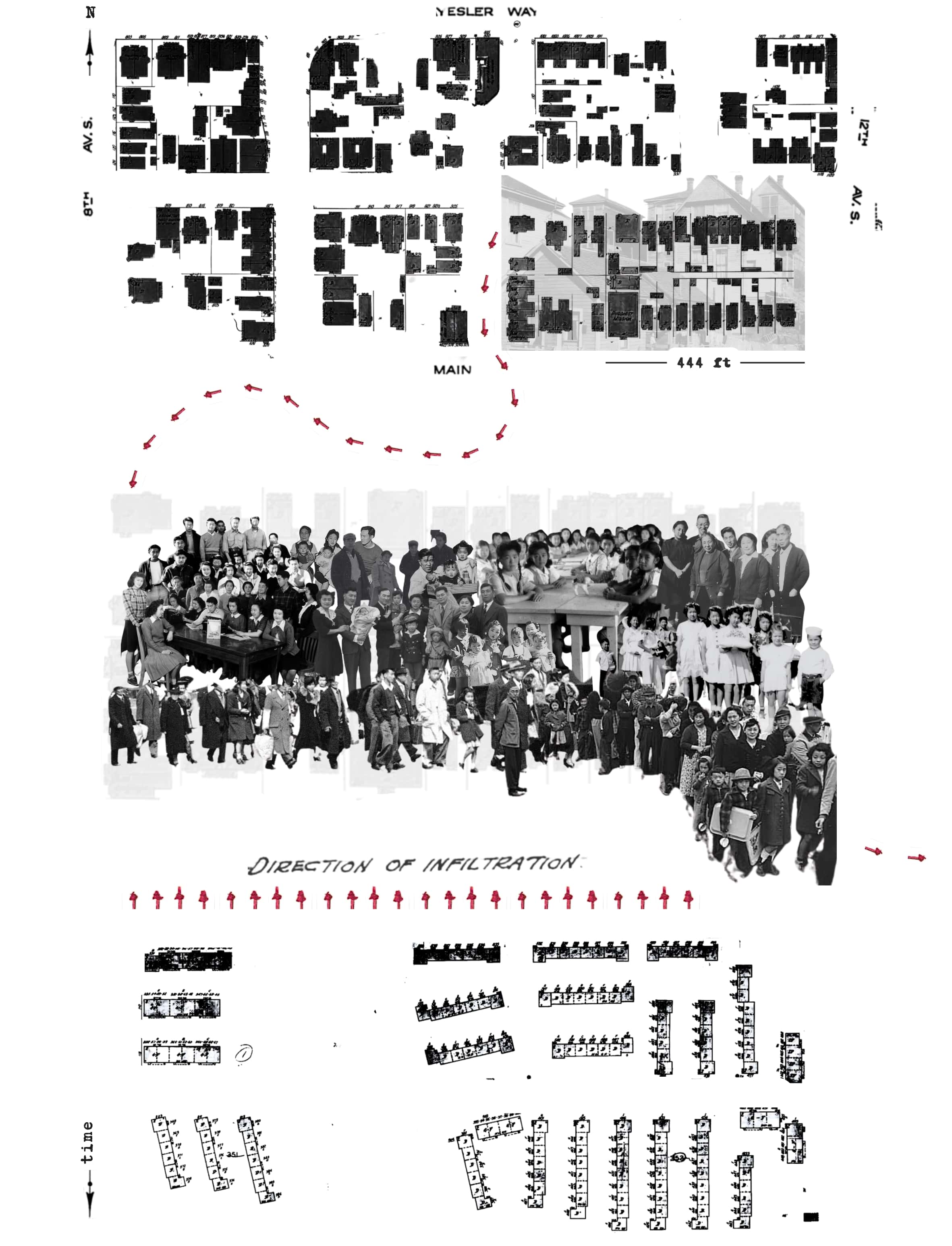
Part of a much larger archival and geo-analytical project undertaken to visualize the magnitude of Japanese American life and loss in Seattle's Nihonmachi (Japantown) throughout WWII's forced incarceration. Here, an erstwhile block of Nihonmachi is selected, and an approximate headcount of dispossession is represented one-to-one using an overlay of archival photography on Sanborn Map extracts. Elements from contemporaneous HOLC maps are repurposed to challenge the dominant narrative of the day. What was a veiled force of racial urbanism is turned overt. Abstraction is defied.
This collage uses the following sources – the photo of pre-war housing in the background of the first panel is from UW's Special Collections, 1940-43. The first and third panels display the full eight-block stretch between 8th and 12th, Main and Yesler, drawing from the 1916 and 1950 Sanborn maps, respectively. The first and second panel (the latter at high transparency) show a subsection of the 1916 Sanborn map that zooms in on the bottom rightmost two blocks. The red arrows and "Direction of Infiltration" label are extracts from the 1936 HOLC Racial Map. The groups of people collaged over the second panel are as follows (left to right, top to bottom): the 1943 staff of the homegrown internment newspaper Minidoka Irrigator (c.o. Densho); the Yamaguchi family in their room at Minidoka (c.o. Wing Luke Museum); a snowball fight at Minidoka (c.o. Densho); a family on their porch (c.o. North Shore Productions); elementary school class at Minidoka (c.o. Densho); the Suzuki family posing in front of barracks at Minidoka (c.o. Densho); the 1944 staff of the Minidoka Irrigator (c.o. Densho); Dan Sakura family photo at Minidoka (c.o. Sakura); Larry Matsuda family photo at Minidoka (c.o. Matsuda); elementary school princesses at Minidoka (c.o. Densho); the U.S. Army’s mass removal of Japanese American residents (c.o. Associated Press); incarcerees lined up outside a mess hall at Puyallup Holding Facility (c.o. MOHAI).
← back